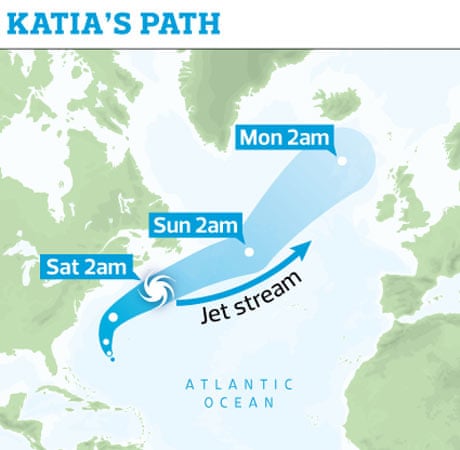
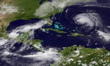
Severe gales and flooding are expected to hit parts of the UK as hurricane Katia makes its way across the Atlantic.
Winds of up to 80mph are predicted to hit north-west Scotland by Monday, with Northern Ireland, north Wales and northern England also likely to be affected.
Forecaster Michael Dukes, of MeteoGroup UK, said: "It looks likely that this will be a significant storm event for mid-September. Strong winds have been predicted that could result in trees coming down, causing major structural damage and travel delays. Inevitably, with the remnants of a tropical storm, there will also be a risk of flash flooding.
"The hurricane is moving slowly at the moment and current predictions show that the remnants of the storm will hit north-west Scotland by Monday."
While it is rare for so-called "warm core" hurricanes to turn into "cold core" hurricanes crossing the Atlantic, rather than declining into a depression, unusual weather conditions have made Katia more threatening. It is the second major Atlantic hurricane of this year's season and caused 90mph winds and 20ft waves in the United States.
The storm will hit the west coast of Ireland first. "This is on the way and it is a significant storm," Met Éireann forecaster Gerry Murphy said. His organisation is predicting winds of 100mph, with the north seeing the worst winds.
By the time Katia reaches the UK on Monday, it is expected to have declined from a category four hurricane – the maximum on the scale is five – to a strong post-tropical storm.
On Saturday morning Katia remained a category one hurricane and was accelerating north-eastwards. It is expected to make landfall in Ireland around dawn on Monday. Tropical hurricanes are usually slow-moving phenomena, fuelled by warm seas and humid air, which fizzle out as they move north into the colder air of the Atlantic.
In Katia's case, it appears that unusually low-altitude and strengthening jet stream winds between North Carolina and New York are speeding its passage towards Ireland and the UK and allowing it to maintain an unusual intensity.
Tom Tobler, of MeteoGroup, said: "It is looking like the storms will hit early on Monday morning, with the most severe weather coming in the middle of the day. Gusts of over 60mph will be seen quite widely over northern and central Scotland and Northern Ireland and even down into northern England.
"The maximum gusts in western Scotland could easily get up to 75mph or 80mph and potentially it could get above that. It could cause disruption and uproot trees, especially as they still have a lot of leaves on, being early autumn."
Forecasters say the predicted high winds could coincide with high tides and western coasts in particular are at risk from localised flooding.
An Environment Agency spokesman stated: "At present there is a low risk of flooding across the north coast of Wales and the north-west coast of England during Monday from strong to gale force winds, large waves and a surge which coincides with a period of spring tides."


Comments (…)
Sign in or create your Guardian account to join the discussion