Story highlights
NEW: Arthur made landfall near Cape Lookout at about 11:15 p.m.
Hurricane Arthur became a Category 2 storm Thursday night
CNN meteorologist says most dangerous part of the storm is hugging the coast
Resident who lives 34 miles offshore says waves have been 35 feet high
Sherman Lee Criner is vacationing in a bull’s eye. Emerald Island, North Carolina, is just west of where Hurricane Arthur came ashore late Thursday with 100 mph winds.
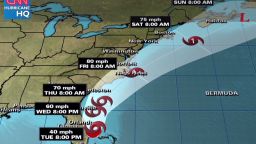
The Category 2 storm made landfall at 11:15 p.m. between Cape Lookout and Beaufort, the National Hurricane Center said. Arthur was charging to the northeast at 15 mph.
Criner didn’t plan it to be right in its path. He asked his two children and niece where they wanted to spend the holidays, they voted for the beach and he granted the wish.
He thought of canceling the trip as the storm brewed but decided against it.
“It’s a doable storm,” Criner said.
The lawyer lives in Wilmington and has sat out hurricanes before. He also felt confident sturdiness of their accommodations of concrete and steel.
“We’re in an 8th floor condominium,” he said. When Arthur’s eye wall hits, he will wake up son Sherman, 9, daughter Elizabeth, 14, and niece Mary Brown, 10.
They’ll to look out the window at the surf below, as the storm surge pushes it up Indian Beach.
Stormy holidays
Other vacationers hunkered down in hotels along the North Carolina coast Thursday evening as Hurricane Arthur grew into a Category 2 storm.
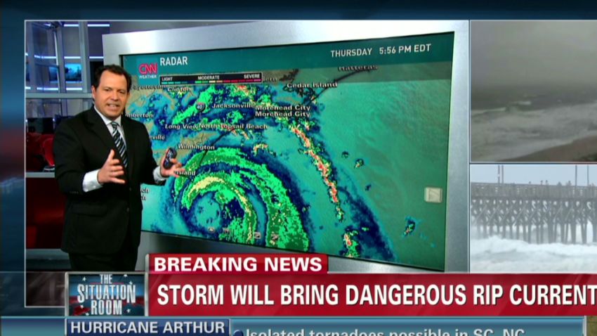
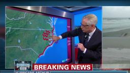
CNN severe weather expert Chad Myers said the storm was getting more dangerous as it developed an inner eye wall.
“That’s concerning, because the smaller the eye gets, the stronger the winds get,” he said.
Hurricane Arthur was bearing down on Morehead City, a popular vacation site for the Fourth of July.
“The dangerous part of this storm is going to travel right along the coast,” he said.
Rain was intermittently heavy throughout the day in much of the southeastern parts of the state.
The National Weather Service in Wilmington said 1 1/3 inches of rain fell during one hour Thursday afternoon. The office also tweeted that there was some flooding just south of downtown.
The storm’s strongest sustained winds were 100 mph.
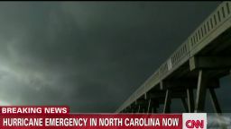
North Carolina Gov. Pat McCrory told residents and tourists to stay inside while it was dark outside. He said the potential track for the storm would move it closer to land.
“We did not expect this western movement,” he told reporters Thursday night. “So we’re most concerned now about flooding inland and storm surges in our sounds and in our rivers.”
There were no immediate reports of injuries and some counties reported only minimal damage.
The good news: the storm hit Thursday at low tide, the governor said. The bad news: the storm was now stronger.

CNN correspondents at Wrightsville Beach near Wilmington and Atlantic Beach said most people in those two tourist destinations were heeding authorities’ calls to stay out of the surf.
But people were getting out on the sand to see the dark clouds roll in before heading in for the night.
“We are starting to see the water come up a little further,” said Marc Leford, the facilities manager at the Shell Island Resort in Wrightsville Beach. “The guests are hanging tight. They seem to be having a good time. They’re ready to wait it out.”
At the Frying Pan Tower, 34 miles offshore from Wilmington, Richard Neal said the winds had shaken the old Coast Guard light station enough to cause some apprehension.
Neal has turned the tower into an “adventure bed and breakfast.”
But after 99 mph winds and 35-foot waves, he said, “We were not expecting it to be this much of an adventure.”
Neal said there were no guests there and he and his children were sitting around playing cards as the eye passed through.
He warned people on land to evacuate.
“These are very large waves and the swells are enormous,” he said.
Arthur is expected to bring storm surges of up to 7 feet, as well as large, damaging waves, high winds and dangerous rip currents that authorities warned could sweep even the strongest swimmers out to sea.
Hurricane warnings were up for most of the state’s coastline. Parts of Massachusetts, South Carolina and Virginia were under tropical storm warnings. The National Hurricane Center said the storm was moving to the north-northeast.
A tornado watch was in effect for 10 counties of North Carolina.
McCrory declared a state of emergency for 23 eastern counties. As of Thursday evening, at least 7,200 customers of two of the largest power companies in the Wilmington area were without power.
Up the coast in Hyde County, authorities instituted a 12-hour curfew beginning at 8 p.m. ET.
Earlier in the day, authorities issued a mandatory evacuation order for Hatteras Island and a voluntary evacuation order for Ocracoke Island, both in North Carolina’s Outer Banks.
Some of those residents headed north to Kill Devil Hills and other communities and found a hotel room to wait out the storm.
Holiday impact

The storm interrupted some holiday plans, including a decision by the town of Surf City, North Carolina, to scrap its planned Thursday night Fourth of July show.
The city’s website said the storm’s fury is likely to be short-lived and encouraged visitors to keep their beach vacation plans: “Surf City is very much open for business.”
But vacationers should not take the warm welcome as an all clear. To avoid tragedy, they should stay on land.
The storm is expected to spawn deadly rip currents: rapid flows of water from the shore back out to the ocean that can pull people to sea and exhaust even the strongest swimmers.
Tropical cyclones killed six people in 2009, the National Weather Service said. All drowned in large waves or rip currents.
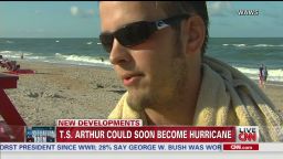
Despite the warnings, a handful of families frolicked in the surf Thursday in Atlantic Beach, North Carolina.
Among them was Derek Cornwall’s family, who arrived for vacation in the resort town late Wednesday.
“We were banking on a couple of hours today before the storm moves in,” he said.
His daughter, Hannah, was taking full advantage, playing in the waves despite being “a little nervous” about the storm.
“But I’m actually kind of excited because I’ve never been in a severe storm,” she said. “It’s kind of on my bucket list.”
Robin Banning, her children and a friend planned to ride out the storm at a Walmart parking lot in Kill Devil Hills, North Carolina. They had relocated there from an RV campsite closer to where the storm is expected to hit, but didn’t want to go home to Virginia.
“I lived through Bertha,” she said, referring to the 2008 hurricane that killed three people. “This is good. It’s just rain.”
See Images as CNN crews cover Hurricane Arthur
Keeping the Boston Pops dry
Despite the risks farther south, the storm shouldn’t force a total washout of East Coast Independence Day celebrations.
With rain forecast for parts of New England on Friday, the annual Fourth of July Boston Pops concert was moved to Thursday.
If it rains then, the fireworks part of the show can start, but the concert may have to go, event organizer Rich MacDonald told CNN affiliate WCVB. “It affects the instruments, and these instruments are valuable and old.”
In the nation’s capital, the weather looks cheerier for the holiday.
The slight chance of rain during the day Friday will vanish by night, leaving clear skies for the rockets’ red glare of fireworks over the National Mall.
However, Thursday’s rehearsal was closed to the public because of storms.
Keep a hurricane preparation checklist
Staying safe when the lights go out
What you need to know about Independence Day
CNN’s Rene Marsh, Eric Fiegel, Steve Almasy, Joe Johns, Brian Rokus, Joe Sutton, Lisa Desjardins, Jason Hanna, Sunlen Serfaty and Paul Courson contributed to this report.