MIAMI, Florida (CNN) -- Hurricane Bill churned in the Atlantic Ocean toward the west-northwest as a major Category 3 hurricane Tuesday evening.
Hurricane Bill is expected to continue toward the northwest Tuesday night and Wednesday.
Around 8:30 p.m., reports from a National Oceanic and Atmospheric Administration plane indicated Bill had strengthened, with maximum sustained winds near 125 mph. The National Hurricane Center said further strengthening is possible.
When a hurricane's sustained winds reach 111 mph, it reaches Category 3 status. When sustained winds reach 131 mph, it becomes a Category 4 storm.
The center said Bill is a large storm, with hurricane force winds extending outward up to 45 miles (75 kilometers). Tropical force winds extend outward up to 175 miles (280 kilometers).
The hurricane center expects Bill to turn to the northwest Wednesday.
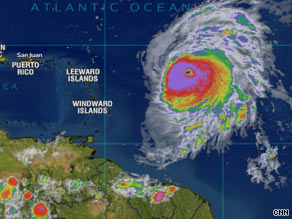
"On this track, the core of Bill will be passing well to the northeast of the northern Leeward Islands late Wednesday and early Thursday," forecasters said. The northern Leeward Islands are to the east of Puerto Rico.
Weather models showed the storm also missing Bermuda as it heads nearer to the upper U.S. East Coast, CNN meteorologists said Tuesday.
Although Bermuda may escape a direct hit from Bill, it might experience strong waves and fierce winds, meteorologists said. ![]() Track Hurricane Bill's path across the Atlantic »
Track Hurricane Bill's path across the Atlantic »
No computer models Tuesday showed Bill posing a danger to the United States.
Bill, the first hurricane of the 2009 Atlantic season, was heading west-northwest at near 16 mph as of Tuesday afternoon. It was centered about 635 miles east of the Leeward Islands.
Hurricane-force winds extended up to 45 miles from the center, and tropical storm-force winds of at least extended up to 175 miles out.

The remnants of Tropical Depression Ana continued to drop heavy rain across Hispaniola and Cuba on Tuesday, CNN meteorologists said. Forecasters expect Ana to wash South Florida in heavy rain as it passes through the Keys this week.
There's a slight chance that Ana could regenerate into a tropical cyclone after it moves into the southeastern Gulf of Mexico this week, the weather service said.
All About National Hurricane Center • Weather

 Sit tight, we're getting to the good stuff